Kawerau - From Wikipedia, the free encyclopedia
Kawerau is a town in the Bay of Plenty region of the North Island of New Zealand. It is situated 100 km south-east of Tauranga and 58 km east of Rotorua. It is the seat of the Kawerau District Council, and the only town in Kawerau District.
Kawerau is a small community, with an economy that is largely driven by the nearby pulp and paper mill that is run by Norske Skog and Carter Holt Harvey. It is located along State Highway 34, southwest of Onepu, and is the terminus of the East Coast Main Trunk Railway, and the commencing point of the Murupara Branch railway.
Kawerau was one of the worst-affected towns in the 1987 Edgecumbe earthquake.
History and culture:
European settlement:
Kawerau, one of the youngest towns in New Zealand, was founded in 1953 as a mill town for the new Tasman pulp and paper mill. The site for the mill was chosen because of the ready availability of geothermal energy, water from the Tarawera River and the large supply of pine timber from the nearby Kaingaroa Forest.
Unlike most other towns of its size, Kawerau was carefully planned before construction. The town was built with an impressive number of facilities, to accommodate a multinational specialist workforce. The mill continues to drive the local economy and greatly influences the fortunes of the town. The town's population peaked in the early 1980s (8718 in the 1981 census) but has declined significantly since then due to the restructuring of the mill and of associated industries.
Recent history:
In 2012 mill owner Norske Skog said it would be shutting one of the two newsprint machines at the mill. In January 2013 it was confirmed nearly half the mill's jobs would be lost.
Norse Skog of Norway which is the world's second biggest producer of newsprint confirmed closure of one of its two paper machines at the Tasman Mill at Kawerau with the loss of 110 jobs. The company first announced its intention to shut one machine last September, following a review of its newsprint capacity in Australasia. The remaining Tasman machine would continue to produce newsprint predominantly for the New Zealand and Australian markets. Norske Skog management would work closely with employees, unions and other stakeholders on the detailed closure arrangements, including a mill-wide restructuring programme. Peter McCartey, General Manager of Tasman Mill said it was widely understood the decision had been brought about by global market forces within the industry. The second paper machine had operated successfully for over 50 years. Norske Skog has the widest geographical spread of all the paper producers, with mills in 11 countries on all continents except Africa.
Kawerau is also home to geothermal power supply Kawerau Power Station for the local industry as well as the rest of New Zealand.
Marae:
The local marae, Tohia o te Rangi, is affiliated with the Ngāti Tūwharetoa hapū of Ngāi Tamarangi. It features the Waitaha Ariki Kore meeting house.
Demographics:
Kawerau District had a population of 7,146 at the 2018 New Zealand census, an increase of 783 people (12.3%) since the 2013 census, and an increase of 225 people (3.3%) since the 2006 census. There were 2,499 households. There were 3,540 males and 3,606 females, giving a sex ratio of 0.98 males per female. Of the total population, 1,716 people (24.0%) were aged up to 15 years, 1,275 (17.8%) were 15 to 29, 2,733 (38.2%) were 30 to 64, and 1,425 (19.9%) were 65 or older. Figures may not add up to the total due to rounding.
Ethnicities were 52.3% European/Pākehā, 61.7% Māori, 4.6% Pacific peoples, 3.0% Asian, and 1.1% other ethnicities. People may identify with more than one ethnicity. Kawerau is one of the three localities in the country with a Māori-majority populace (the others being Wairoa and Ōpōtiki).
The percentage of people born overseas was 10.1, compared with 27.1% nationally.
Although some people objected to giving their religion, 48.9% had no religion, 29.5% were Christian, and 11.7% had other religions.
Of those at least 15 years old, 390 (7.2%) people had a bachelor or higher degree, and 1,542 (28.4%) people had no formal qualifications. The median income was $20,600. The employment status of those at least 15 was that 1,857 (34.2%) people were employed full-time, 684 (12.6%) were part-time, and 549 (10.1%) were unemployed.
Geography:
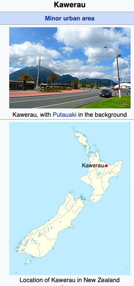
The 820 m volcanic cone of Mount Edgecumbe/Putauaki lies 3 km to the east of Kawerau, and is easily visible from the town. The Tarawera River straddles Kawerau to the east and continues north to the Bay of Plenty. Water is supplied to the town from two natural springs. Kawerau's water was judged the best-tasting in New Zealand in 2003 and 2004.
Kawerau has access to vast geothermal resources. There are a number of geothermal hot springs in the surrounding bush owned and operated by local families. The Kawerau geothermal field provides steam power for the paper mill, and a 90 MW geothermal power station is currently under construction.
The District has a land area of 21.9357 km² (8.4694 sq mi), making it the smallest territorial authority in New Zealand in terms of land area. It is completely surrounded by the Whakatāne District.
Climate:
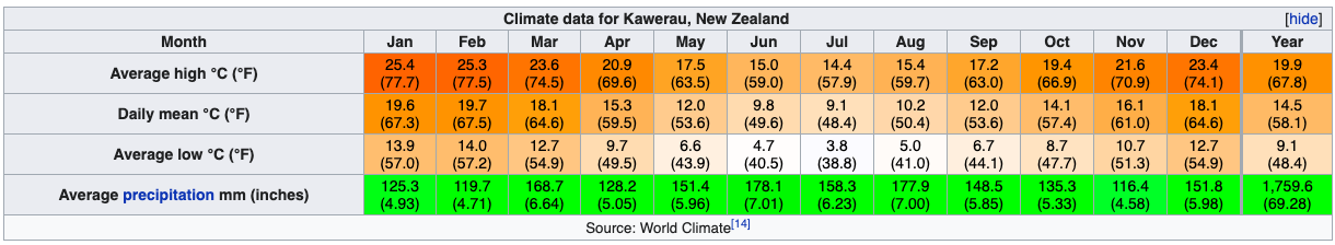
During summer (December to February), the average daily maximum temperature in Kawerau is 23.7 °C. In January 2008, the temperature exceeded 30 °C on five days. In winter (July to August) crisp early morning frosts are usually followed by clear, sunny days, and the average daily maximum temperature is around 15.6 °C.
Rainfall is spread throughout the year, though it is not uncommon to experience a drought during summer.
Events:
Kawerau hosts a number of events each year, including the National Woodskills Festival, 'King of the Mountain' race and the Tarawera 100 motorcycle endurance race. Kawerau is also growing as an event venue for white water rapid competitions such as kayaking and rafting. Kawerau was a venue for the 2013 World Rafting Championships.
Kawerau Woodfest & National Woodskills CompetitionThe National Woodskills Festival is a competition that encompasses a broad spectrum of wood craftsmanship and wood art. Some of the competitors are professionals but many are amateurs. The Woodskills Festival was first held in Kawerau in 1989 as a local competition. By 1991, the event had become such a popular annual competition that it was developed into a national event, attracting exhibitors from throughout New Zealand. The competition has now developed into a broader range of attractions which captivates many skills from the Forestry Industry and now takes over the town for the weekend, in what is known as Kawerau Woodfest.
The annual Kawerau Woodfest attracts hundreds of visitors from around the country making it the town's largest event and as a result is the highest economic beneficial event in Kawerau. As well as the Woodskills Festival there is an Arts & Crafts Festival with displays open on Saturday and Sunday at various venues around Kawerau.
Notable residents:
Kawerau is a town in the Bay of Plenty region of the North Island of New Zealand. It is situated 100 km south-east of Tauranga and 58 km east of Rotorua. It is the seat of the Kawerau District Council, and the only town in Kawerau District.
Kawerau is a small community, with an economy that is largely driven by the nearby pulp and paper mill that is run by Norske Skog and Carter Holt Harvey. It is located along State Highway 34, southwest of Onepu, and is the terminus of the East Coast Main Trunk Railway, and the commencing point of the Murupara Branch railway.
Kawerau was one of the worst-affected towns in the 1987 Edgecumbe earthquake.
History and culture:
European settlement:
Kawerau, one of the youngest towns in New Zealand, was founded in 1953 as a mill town for the new Tasman pulp and paper mill. The site for the mill was chosen because of the ready availability of geothermal energy, water from the Tarawera River and the large supply of pine timber from the nearby Kaingaroa Forest.
Unlike most other towns of its size, Kawerau was carefully planned before construction. The town was built with an impressive number of facilities, to accommodate a multinational specialist workforce. The mill continues to drive the local economy and greatly influences the fortunes of the town. The town's population peaked in the early 1980s (8718 in the 1981 census) but has declined significantly since then due to the restructuring of the mill and of associated industries.
Recent history:
In 2012 mill owner Norske Skog said it would be shutting one of the two newsprint machines at the mill. In January 2013 it was confirmed nearly half the mill's jobs would be lost.
Norse Skog of Norway which is the world's second biggest producer of newsprint confirmed closure of one of its two paper machines at the Tasman Mill at Kawerau with the loss of 110 jobs. The company first announced its intention to shut one machine last September, following a review of its newsprint capacity in Australasia. The remaining Tasman machine would continue to produce newsprint predominantly for the New Zealand and Australian markets. Norske Skog management would work closely with employees, unions and other stakeholders on the detailed closure arrangements, including a mill-wide restructuring programme. Peter McCartey, General Manager of Tasman Mill said it was widely understood the decision had been brought about by global market forces within the industry. The second paper machine had operated successfully for over 50 years. Norske Skog has the widest geographical spread of all the paper producers, with mills in 11 countries on all continents except Africa.
Kawerau is also home to geothermal power supply Kawerau Power Station for the local industry as well as the rest of New Zealand.
Marae:
The local marae, Tohia o te Rangi, is affiliated with the Ngāti Tūwharetoa hapū of Ngāi Tamarangi. It features the Waitaha Ariki Kore meeting house.
Demographics:
Kawerau District had a population of 7,146 at the 2018 New Zealand census, an increase of 783 people (12.3%) since the 2013 census, and an increase of 225 people (3.3%) since the 2006 census. There were 2,499 households. There were 3,540 males and 3,606 females, giving a sex ratio of 0.98 males per female. Of the total population, 1,716 people (24.0%) were aged up to 15 years, 1,275 (17.8%) were 15 to 29, 2,733 (38.2%) were 30 to 64, and 1,425 (19.9%) were 65 or older. Figures may not add up to the total due to rounding.
Ethnicities were 52.3% European/Pākehā, 61.7% Māori, 4.6% Pacific peoples, 3.0% Asian, and 1.1% other ethnicities. People may identify with more than one ethnicity. Kawerau is one of the three localities in the country with a Māori-majority populace (the others being Wairoa and Ōpōtiki).
The percentage of people born overseas was 10.1, compared with 27.1% nationally.
Although some people objected to giving their religion, 48.9% had no religion, 29.5% were Christian, and 11.7% had other religions.
Of those at least 15 years old, 390 (7.2%) people had a bachelor or higher degree, and 1,542 (28.4%) people had no formal qualifications. The median income was $20,600. The employment status of those at least 15 was that 1,857 (34.2%) people were employed full-time, 684 (12.6%) were part-time, and 549 (10.1%) were unemployed.
Geography:
The 820 m volcanic cone of Mount Edgecumbe/Putauaki lies 3 km to the east of Kawerau, and is easily visible from the town. The Tarawera River straddles Kawerau to the east and continues north to the Bay of Plenty. Water is supplied to the town from two natural springs. Kawerau's water was judged the best-tasting in New Zealand in 2003 and 2004.
Kawerau has access to vast geothermal resources. There are a number of geothermal hot springs in the surrounding bush owned and operated by local families. The Kawerau geothermal field provides steam power for the paper mill, and a 90 MW geothermal power station is currently under construction.
The District has a land area of 21.9357 km² (8.4694 sq mi), making it the smallest territorial authority in New Zealand in terms of land area. It is completely surrounded by the Whakatāne District.
Climate:
During summer (December to February), the average daily maximum temperature in Kawerau is 23.7 °C. In January 2008, the temperature exceeded 30 °C on five days. In winter (July to August) crisp early morning frosts are usually followed by clear, sunny days, and the average daily maximum temperature is around 15.6 °C.
Rainfall is spread throughout the year, though it is not uncommon to experience a drought during summer.
Events:
Kawerau hosts a number of events each year, including the National Woodskills Festival, 'King of the Mountain' race and the Tarawera 100 motorcycle endurance race. Kawerau is also growing as an event venue for white water rapid competitions such as kayaking and rafting. Kawerau was a venue for the 2013 World Rafting Championships.
Kawerau Woodfest & National Woodskills CompetitionThe National Woodskills Festival is a competition that encompasses a broad spectrum of wood craftsmanship and wood art. Some of the competitors are professionals but many are amateurs. The Woodskills Festival was first held in Kawerau in 1989 as a local competition. By 1991, the event had become such a popular annual competition that it was developed into a national event, attracting exhibitors from throughout New Zealand. The competition has now developed into a broader range of attractions which captivates many skills from the Forestry Industry and now takes over the town for the weekend, in what is known as Kawerau Woodfest.
The annual Kawerau Woodfest attracts hundreds of visitors from around the country making it the town's largest event and as a result is the highest economic beneficial event in Kawerau. As well as the Woodskills Festival there is an Arts & Crafts Festival with displays open on Saturday and Sunday at various venues around Kawerau.
Notable residents:
- Danielle Hayes, model
- Gill Gatfield, sculptor
- John Rowles, singer
- Ria van Dyke, model
- Sarah Walker, Women's BMX world champion
History of Kawerau
Before the town and mill were established the district was known as Onepu. Then in 1953, the New Zealand Geographic Board applied the name Kawerau to the new town and district.
Kawerau was a grandson of Toi Kai Rakau, who arrived in New Zealand about 1150 and from whom many of the present tribes of the Bay of Plenty claim descent.
Boundaries were defined when Tuwharetoa claimed the old Rangitaiki River boundary as its eastern border and Matata as its seaboard. Tuwharetoa's territory extended west along the coast to Otamarakau, southeast to Maungawhakamana and across to Putauaki.
When the sons of the ancestor Tuwharetoa moved from Kawerau to the Lake Taupo region, those who remained held fast to their ancestral name, which the two groups now share. Tuwharetoa ki Kawerau and Tuwharetoa ki te Tonga have, for geographic and other reasons, developed separately as important tribal entities but remain united in their genealogy.
There are several archaeological sites in the Kawerau district and indicate a large community occupied the area. A totara canoe covered by about 30cm of volcanic ash and 70cm of peat was found near the foot of Putauaki (Mt. Edgecumbe) suggesting a large pa existed on the site.
In the early 1930s Percy Fenton, a saw miller in the Bay of Plenty, acquired the cutting rights for 1500 acres of dense rimu bush at Te Haehaenga. The block was above the headwaters of the Tarawera River behind Lake Okataina. To set up the mill and associated facilities for its workers and their families, and to get the timber to market, Fenton had to build and maintain a 17.5km stretch of road, which included the strengthening of two bridges.
By 1935 New Zealand's economy was improving and things were looking up for the mill. The then- Whakatane County Council built a steel bridge across the Tarawera River near Waterhouse Street, to give better access to the area. It then extended the road from the Maori Affairs Block to the new bridge. Percy Fenton further extended the road to reach the mill. This became known as Fenton Mill Road.
In the early 1950s, the government and the Fletcher Company were involved in planning a pulp and paper mill adjacent to Onepu on the banks of the Tarawera River. This led to the formation of the Tasman Pulp and Paper Company (now Norske Skog Tasman / Carter Holt Harvey Tasman) in 1952. The residential area ofthe town was laid out and buildings established under control ofthe Ministry of Works.
The Kawerau borough was officially created in April 1954 and managed by a government- appointed town commissioner. In November 1955, a public meeting elected eight people on to an advisory committee to support the commissioner. In 1968 this system was abolished and a Borough Council comprising a Mayor and 10 Councillors was formed. From then on, the normal borough administration proceeded in terms of the Municipal Corporations Act 1954.
Kawerau district
Kawerau Town at the foot of Mt Edgecumbe (Pūtauaki), 100 km south-east of Tauranga and 58 km east of Rotorua. The settlement developed from 1953, when the Tasman Pulp and Paper Company established a mill to process timber from maturing stands of radiata pine (Pinus radiata) in the state-owned Kāingaroa Forest. The site was chosen because of the availability of geothermal steam as a power source.
Kawerau was laid out with curved streets and many parks, and an impressive range of amenities for its size. Its streets were named after Pākehā governors, governors-general and parliamentarians – a feature at odds with today's predominantly Māori population.
The mill and related businesses have been the largest employers. The decline of the timber industry since the 1980s has seen the population decrease from a peak of 8,593 in 1981 to 6,363 in 2013. The unemployment rate in 2013 was 24.9% (compared with 8.6% for the Bay of Plenty as a whole). 25.8% of Kawerau’s population were under 15. 54.6% identified themselves as Māori and 45.8% as European. There is some in-migration from retired people seeking affordable and well-built houses in a pleasant environment.
Mt Edgecumbe (Pūtauaki)821-m volcano, which forms part of the ‘line of fire’ from Mt Tongariro, through Tauhara and Tarawera mountains to Whakaari (White Island).
The mountain was named Edgecumbe by Captain James Cook, probably after George, second baron Edgecumbe, who had become an admiral in 1761. On 2 November 1769 Cook observed that ‘seemingly at no great distance from the sea is a high round mountain which I have named Mount Edgcomb … it stands in the middle of a large plane [sic] which makes it the more conspicuous’.
In fact the mountain is on the edge of both the Rangitāiki Plains and the Volcanic Plateau, not far from the Tarawera River where it passes Kawerau. Known to Māori as Pūtauaki, it is of particular significance to the tribes of Ngāti Awa and Ngāti Tūwharetoa ki Kawerau. It is also an important ancestral mountain for Ngāti Apa of the Rangitīkei region in the south-west of the North Island. There is no recent eruption history.
